Hello friends first of all I want to invite you to come to my mexico to know, in this blogger they will disclose some places of my very touristic and beautiful mexico that makes us feel proud of mexico, hope they can be convinced that someday if they travel mexico come to a place full of beautiful cultural sites, tourist, full of flora and fauna.
CESAR IGNACIO TORRES FLORES (TAMPICO, TAMAULIPAS)
PERLA KARINA SIFUENTES VALDEZ (Cd, VICTORIA , TAMAULIPAS)
JOSE AGUSTIN LOPEZ MENDOZA
GUILLERMO DANIEL PEQUEÑO FUENTES (MAZATLAN, SINALOA)
Perla Karina Sifuentes Valdez

Is the
capital city of the Mexican state of Tamaulipas. It is located in the
western-central region of the state. Ciudad Victoria is also the municipal seat
of the surrounding Victoria Municipality, which covers an area of 1,638 km²
(632.4 sq mi). According to the 2010 INEGIpopulation count, the city had
305,155 inhabitants, and the Victoria Municipality had a population of
321,953.The city and the municipality both rank fourth in population size in
the state, behind Reynosa, Matamoros, and Nuevo Laredo.
Geography

Victoria is
located 316 metres (1,037 ft) above sea level and at coordinates 23°44′N 99°8′W
just north of the Tropic of Cancer. The city is in a valley between two
mountain ranges: theSierra Madre Oriental to the west and the Sierra de
Tamaulipas to the east.
I want to go back to victory but not yet because even not go on
vacation
For me when I went to victory chirrito the weather was very nice I loved it , the location was a bit far from where I come matamoros but still went and it was a very
nice and beautiful with my family.
Climate
Victoria
has short mild winters and long hot summers. Temperatures rarely drop below 0
°C (32 °F) — the lowest recorded temperature was −6 °C (21 °F) and the hottest
was 48.5 °C (119.3 °F), one of the highest temperatures ever recorded in Mexico.
The average annual precipitation is 700 millimeters (28 in). Half of this
amount falls between May and September, although there is a drying trend in
July. Its Köppen climate classification is Cwa or humid subtropical, its
moderate elevation adds to overall precipitation pattern. Exceptionally heavy
rains brought by occasional North Atlantic tropical cyclones also influence the
overall climate and precipitation amounts.

Nacia not yet cuanod my dad went to heaven to Victoria , but the pass very well only that it was very cold.
''El cielo''
The main attraction of Tamaulipas in Mexico’s far northeast is the Unesco-listed biosphere reserve of El Cielo, encompassing 1445-sq-km of steep-sided forested mountains ranging from 200m to 2320m. Marking a transition zone between tropical, temperate and semidesert ecosystems, its diversity is incredible. There are 97 species of reptile and amphibian and 430 bird species including the Tamaulipas pygmy owl and yellow-headed parrot. Black bear and jaguar also inhabit the reserve, and there are dozens of orchid varieties (picking them is prohibited), mostly within the cloud-forest zone between 800m and 1400m.
 Inside the park there are trails which take you to weird rock formations, caves and waterfalls, and pools where you can swim. In Gómez Farías, the main base for launching park excursions, the fancy Cumbres Inn & Suites can help arrange kayaking trips within the park. There’s a restaurant here with valley views, a rappelling wall, a triple zip-line, and ropey mountain bikes for rent.
I could not go with my dad to heaven as yet had no one year old.
My dad has going in El Cielo with yours friends.
Malls

For the tourist find different products, from food to souvenirs dishes, Ciudad Victoria offers splendid plazas and malls ideal for shopping.
Soriana Tamatán
Calzada Luis Caballero No. 250, corner of Rio Corona, Fracc. zozaya
Wal Mart
Lopez Mateos No. 3630 Blvd., Unit Housing Fidel Velasquez

Albercas
Ciudad Victoria is recommended to visit spas high quality and suitable for all ages, reserving some not suitable for minors. The state capital offers the following recreational facilities:
Olympic Pool Marte R. Gomez
19 Mina and Berriozabal Sapimundo
Km 10 Carretera Victoria Matamoros, Fracc. Agricultural Los Olivos
Pool Sports Complex XXI Century
Fidel Velasquez Blvd. S / N, Col. Horacio Tera
 Recreational Sites Water
Around Ciudad Victoria is a lot of options to dive into the water, swimming quietly, or scouring the water aboard a boat. Dams, rivers or the beach offer visitors. For more information regarding fishing and hunting, which are the main attraction of some of these places, see Section Activities.
Presa Vicente Guerrero
Located south of Ciudad Victoria, in the municipality of Padilla and within the Rio Purification, the Presa Vicente Guerrero is one of the largest in the state and one of the most recognized nationally for its resources in fishing, as well to have the largest number of hunting areas for hunting birds, which convenes annually thousands of hunters. Its approximate surface is about 40 thousand hectares, where largemouth bass and other species such as crappie and catfish, is the target of fishermen.
Knights dam
Interejidal towards the Dam Road is the Knights, where travelers can find places for camping and species like egrets, gray and ducks, besides the dam water is swimmable.
Natural Spa Los Nogales


It is located in the municipality of Jaumave, northwest of the city of Victoria. It is a resort where two channels of a river with temperatures contrary bind, so the interesting clash of currents make the traveler can enjoy a rich water in climate, surrounded by the beauty of the place.
My family and I couldn't go to the Natural Spa Los
Nogales yet because it was far from our cabin.
Tourist Parador Florida
Its main attraction is the waterfall El Salto, where tourists take pictures and have fun watching the whimsical waterfalls. The hostel is located forward of the municipality of Jaumave, starting from Ciudad Victoria on Highway to San Luis Potosi. The Parador provides essential services to attract travelers everywhere as comfortable cabins, restaurant, baths bathhouse, as well as horseback riding and excursions to the various natural areas of the municipality of Jaumave, places from where you can appreciate a beautiful macaws streaking the air.
The Chorrito

I have been in El Chorrito with my family.
The Trickle is located 77 km stretch Victoria-Monterrey, and once reaching the town of Tomaseño, 25 km more. It is a cave and spring in a curious way, because for thousands of years, drop by drop was pouring water on a stone grotto up to take the form of a virgin, why he adapted a sanctuary and is visited by thousands of pilgrims every year. Due to religious attraction, tourism has been prepared offering crafts and restaurants to make the trip more comfortable.
I Went shopping at the city center a place Where people spend money on clothes and never buy something cheap.
I could not stay longer as I wanted already it was only input through output

Rios
Around the town of Victoria, the capital city of the state, are located rivers with transparent waters full of life, in which some fish or contemplate the nature around.
Some of the nearby rivers to Victoria to access the traveler could include Purification River, in the municipality of Padilla; Rio Guayalejo located in Llera, River Falls in the town of Abasolo; and Rio Frio, located in the municipality of Gomez Farias.
Restaurant

Installed in front of Tamaulipas Cultural Center and access to the Atrium, this sister restaurant to a prestigious retail chain in the industry, offers to visitors and users a varied menu of food and drinks. Open daily from 7:00 to 23:00 hours.


Installed in front of Tamaulipas Cultural Center and access to the Atrium, this sister restaurant to a prestigious retail chain in the industry, offers to visitors and users a varied menu of food and drinks. Open daily from 7:00 to 23:00 hours.
I was in the middle in a restaurant eating at subway

In my next vacation plans
The next vacations I'll be going to Monterrey with my family
and I want to go to the parks and the "Paseo
de Santa Lucia" since people have told me that is
pretty beautiful Monterrey, I'll be going with some
friends, also I want to go to Michoacan since there I
have some family and the say that the food is
delicious and I'll also visit the family of a friend and
he will show me Michoacan.


Guillermo Daniel Pequeño Fuentes
(Mazatlan, Sinaloa)
Mazatlán is
a Nahuatl word meaning "place of deer".The city was founded in 1531
by an army of Spaniards and indigenous settlers. By the mid-19th century a
large group of immigrants had arrived from Germany. These new citizens
developed Mazatlán into a thriving commercial seaport, importing equipment for
the nearby gold and silver mines. It served as the capital of Sinaloa from 1859
to 1873. The German settlers also influenced the local music, banda, which is
an alteration of Bavarian folk music. The settlers also established the
Pacifico Brewery on March 14, 1900.
With a
population of 438,434 (city) and 489,987 (municipality) as of the 2010 census,
Mazatlán is the second-largest city in the state. It is also a popular tourist
destination, with its beaches lined with resort hotels. A car ferry plies its
trade across the Gulf of California from Mazatlán to La Paz, Baja California
Sur. The municipality has a land area of 3,068.48 km² (1,184.75 sq mi) and
includes smaller outlying communities such as Villa Unión, La Noria, El
Quelite, El Habal and many other small villages. Mazatlán is served by General
Rafael Buelna International Airport.
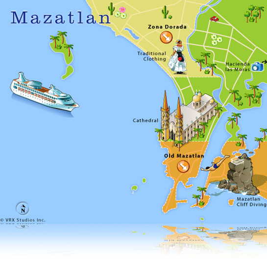
Golden Zone: It is the
traditional zone of tourists, where you find the main hotels, restaurants, bars and
discotheques, skirting the most visited beaches of the seaside resort. The
Golden Zone of Mazatlan is approximately six kilometers from the center of the
city, extending from the Sheik until the Marina El Cid.


Historical Center: Also called
"Pueblo Viejo", the Old Mazatlan envelops the tourist with its
cosmopolitan and colonial charm.

Olas Altas Beach: is
the more traditional beach of Mazatlan, Located in the old part of the city.
Although the beach is small and somewhat difficult for bathrooms, this is a
unique place where they gather the sea and history. The charming promenade high
waves borders the beach, preserving the elegant hotels of
the decade of the 50 and lively bars to cool off

See Mazagua and enjoy all the
attractions we have for you. If you like the thrill, here don't staying the
desire of anything.You are going to be able to have fun in a big way up, down,
shouting and swimming in all our magnificent swimming pools and water slides,
because everything is designed for you to pass great.

I am going to Yucatan that next vacation.
I all be in yucatan by 2018 in the vacation, because i liked to eat their typical food and yours traditions.

Cesar Ignacio Torres Flores
(Tampico, Tamaulipas)
Tampico is
a city and port in the state of Tamaulipas, Mexico; it is located on the north
bank of the Pánuco River, about 10 kilometres (6 mi) from the Gulf of Mexico.
The city is located in the southeastern part of the state, directly north of
the state of Veracruz. Tampico is the fifth-largest city in Tamaulipas with a
population of 297,284. The Metropolitan area of Tampico has 859,419
inhabitants.
In the
early 20th century during the period of Mexico's first oil boom, the city was
the "chief oil-exporting port of the Americas" and the second in the
world, yielding profits that were invested in the city's "grandiose
architecture," often compared to that of Venice and New Orleans. The
first oil well in Mexico was drilled here in 1901 at Ébano. In 1923 the major
oil field dried up, leading to an exodus of jobs and investment.
Economic
development during the 1920s made the city a pioneer in the aviation and soda
industries. The city also is a major exporter of silver, copper, and lumber,
together with wool, hemp, and other agricultural products. Containerized cargo,
however, is mainly handled by the neighboring ocean port of Altamira.

I went with my whole family and had a Tampico Miramar Beach already it was very hot .
I am with my family at the beach and not tampico we are having a good time

I and my family went to the Lake of the Carpenters already there are crocodiles and is very nice to see them
I did not like because we did not went aboard the ship already it was expensive
My family and I on the beach in Tampico watching
strolling tourists

It was not fun for my uncle , I was yet on Because crutches estabe accident and was not Whether well to get to the beach .
I loved going to the beach because it was and yet must be equally nice and clean.

We went to the main square Where there was and already there are squirrels and gave them to eat .
I Could not dance in the square and we had a yet to hurry to my aunt ' s house .
My aunt in the Plaza de Tampico passing of the best in
the background the San Antonio hotel
My aunt in the Plaza de Tampico passing of the best in
the background the San Antonio hotel
PLANS:
in my next vacation I 'm going to Aldama to know their ranches and eat barbecue pansaje and sediment that say it is very rich want to go as soon podible and go to bathe in the beautiful waterfall with my family
Ernesth Reyes Carvajal
(Cancun, Quintana Roo)
 It is a city in the state of Quintana Roo, being head of the
municipality of Benito Juarez, is located in the middle of Mexico, to more than
1,700 km of the City of Mexico. Is the most populous city of the state with 628
306 inhabitants according to the last census of the National Institute of
Statistics and Geography in 2010. Considered an international tourist
destination, with certification of the World Tourism Organization.
It is a city in the state of Quintana Roo, being head of the
municipality of Benito Juarez, is located in the middle of Mexico, to more than
1,700 km of the City of Mexico. Is the most populous city of the state with 628
306 inhabitants according to the last census of the National Institute of
Statistics and Geography in 2010. Considered an international tourist
destination, with certification of the World Tourism Organization.
Geography
 Its geographical
coordinates are 21°09'38"N 86°50'51"OR / 21.16056, -86.8475, and its
altitude ranges from 1 to 8 meters above sea level, due to a slope that grows
from east to west, parallel to the entire city. It is located at a distance of approximately
370 km from the capital of the state Quintana Roo- Chetumal - 70 km from Playa
del Carmen and borders to the east by the Caribbean Sea, to the north with the
municipality of Isla Mujeres, to the west with the municipality of Lazaro
Cardenas, and to the south with the municipality of solidarity. The extension
of the Benito Juarez municipality is 1664 km² and has 22 km of coast.
Its geographical
coordinates are 21°09'38"N 86°50'51"OR / 21.16056, -86.8475, and its
altitude ranges from 1 to 8 meters above sea level, due to a slope that grows
from east to west, parallel to the entire city. It is located at a distance of approximately
370 km from the capital of the state Quintana Roo- Chetumal - 70 km from Playa
del Carmen and borders to the east by the Caribbean Sea, to the north with the
municipality of Isla Mujeres, to the west with the municipality of Lazaro
Cardenas, and to the south with the municipality of solidarity. The extension
of the Benito Juarez municipality is 1664 km² and has 22 km of coast. Climate
The climate of Quintana Roo is hot and humid. The extension
of rainfall is long and goes from May until January although it is not uncommon for rain during the so-called dry months as February, March and April. The hottest months are April and May, up sometimes the temperature until 40º centigrade
.
When my mom
was to Cancun in the last day that was there I take a photo at dawn, she said
that the dawn is very beautiful and that it is nice to see you.
I would like
to see the sunrise already,
but I have not
yet been able to go to Cancun.
Activities
 Diving and snorkeling, Sightseeing tours, Scenic tower, Boat
tours , Bars and discos
Diving and snorkeling, Sightseeing tours, Scenic tower, Boat
tours , Bars and discos
When my mom
was to cancun the led to a tour in a boat that was in the late evening and she
said that is impressive.
I could not
go with my mom because it was a journey of his work and I already had school.
Tourist places
 Isla Mujeres
To only a few minutes
from Cancun, is one of the most beautiful and picturesque islands of Mexico,
with spectacular beaches of low depth and transparent waters and blue. The
streets, houses and shops of Isla Mujeres remember to a small Caribbean people
and has the advantage of not be needed car to enjoy the best of this beautiful
island.
I would like to see the beach
and watch as is the arena, yet can I go on
the following public holidays, already that my mom will be on vacation
Tulum

When my mom
was to tulum said that toward much sun and it was a little far from your hotel
When he went to Tulum my mom
had to get a lot of sunscreen and use a big hat was already
heated and yet everything is excited.
Chichen Itza

Although is not so close to Cancun as other tourist places
of interest, the Mayan ruins of Chichen Itza are some of the most important
attractions of the area. It is located 2 hours from Cancun and the best way to
visit them is through tours or excursions because it facilitates the transfer
and the journey guided the visit and the prices are very competitive, given the
large number of agencies that offer these rides.
My mom could not go to the Chichen Itza because he was very
far from your hotel and i had not paid tours.
I
have never been to the Chichen Itza already
,yet i would like to visit
Gastronomy
 Some of the typical dishes of this idyllic destination are: Tikinxic (fish cooked in Mayan barbecue style), the Bread of dogfish, curried shrimps, the seafood soup, deer and due to its proximity with the Yucatan we also adopted: the cochinita pibil, escabeche Timor, the chirmole, the pipián, the chocolomo, tamales, squid "Tulum," the chachacmall, Chema to Quintana Roo, the mucbipollo, among many others.
My Mom told me that she ate curried shrimps and the seafood soup and who know very well, yet, she likes to eat seafood, already she dont remember more dishes.
MY PLANS
Mazatlan, Sinaloa.

 In my next vacation I would like to go to
Mazatlan because it has many beautiful beaches and i have been told that it
looks very nice to see the sunset from the malecon and has many interesting
places such as: Golden Zone,Historic Center, Beach High waves, The Three
Islands among other exotic places, and also because I would like to know their
culture, traditions and customs and to eat the typical dishes.
In my next vacation I would like to go to
Mazatlan because it has many beautiful beaches and i have been told that it
looks very nice to see the sunset from the malecon and has many interesting
places such as: Golden Zone,Historic Center, Beach High waves, The Three
Islands among other exotic places, and also because I would like to know their
culture, traditions and customs and to eat the typical dishes.JOSE AGUSTIN LOPEZ MENDOZA
(Queretaro, Queretaro)

Queretaro is a great place to start a tour by colonial
Mexico. This beautiful city is inhabited by approximately half a million people
sits at the intersection of two federal highways, 57 (México-Piedras Negras,
Coahuila) and 45 (Portezuelo, Hidalgo-Ciudad Juarez, Chihuahua). Queretaro is
located only two and a half hours (220 km) from the city of Mexico, and that is
why it has become a kind of satellite for the great Mexican capital. Various
manufacturing plants have been established on the outskirts of Queretaro, which
attracts hundreds of businessmen who travel daily from the capital. The
queretana economy is based on agriculture, livestock breeding and the industry.
It was also working stones as the Amethyst, The Opal and topaz. Its mines are
rich in mercury, zinc and lead
The city has preserved its historical center and has
taken measures to beautify it even more. In 1996, the area of Historical
Monuments of Queretaro was classified as a World Heritage Site by UNESCO. Your
registration is based on cultural criteria that the universal considered of
great value and an exceptional example of a colonial city, whose trace
symbolizes to its population of ethnic origins
In the city can also admire beautiful architectural
examples of the XVII and XVIII centuries. Queretaro shelters various treasures
and their inhabitants are proud and friendly ambassadors of them. The historic
center of the city boasts charming colonial mansions, large walkers that invite
you to stroll and picturesque squares that retain their colonial warmth. To get
to know this city, we invite you to address the dual bus that runs its points
floor more attractive.
Queretaro was founded in 1531 by the Franciscan monks.
Literally and metaphorically, the city is an important crossroads in the
history of Mexico. Four of the most significant events for the country occurred
here. The first was the planning of the independence of Spain, in 1810. In 1867, the
Archduke of Austria Maximilian of Habsburg was executed on a hill that
overlooks the city. Finally, here was signed the Constitution of 1917 that
governs the country at present. The state of Queretaro offers a wide variety of
natural attractions, historical and recreational. In the northern part of the
entity is the Sierra Gorda, whose mountains covered with pine cede space to
rolling hills and fertile lands toward the south. The majority of visitors spent a good
part of his time in getting to know the beautiful capital fund, which offers to
the view his charming architecture, and toggles quiet places for the rest with
walkers full of color and colonial details.

For those who practice golf, Queretaro offers 81 holes
of play in excellent fields with all the facilities. The renewed symphony
orchestra is presented in a modern Auditorium Josefa Ortiz de Dominguez. In
Tequisquiapan, spas with thermal waters have acquired a reputation for its
therapeutic benefits. The archaeological zones of Toluquilla and frogs, near
the city of San Joaquin, show the legacy of the chichimecas and huastecos.
México

My brother has already been in México
My brother liked this place
Queretaro

I have traveled to querétaro with my uncle.
I don't remebered this trip, maybe because I was too little
El chorrito Cd. Victoria

My sister and I have visited el chorrito. I have never been
there until this trip.
there until this trip.
I liked this trip. I had so much fun with my sister and the
rest of my family.
rest of my family.
San Fernando

I have visited the rancho of my grandmother since I was
a little boy.
I loved to go to the rancho, because I played with my
cousins.
MY PLANS

In my next vacation I want to go plates as I have been told that is very cute and has marvelous places I want to go with my whole family .

I would like to go to Chiapas
to visit its waterfalls , forests ,
pyramids , stay in hotels in
the city and visit the city.
ISAI LOPEZ (NAYARIT, QUINTANA ROO)
• Golf • SPA • Sailboat • Whale Watching • Fishing • Surf • Meeting with Sea Lions • Tirolesa in the Jungle •Release of baby tortoises • Expedition to the Sierra Madre • ATV Tour • Dining Out •Shopping Cart • Swim with Dolphins • More…
Nayarit is one of the states, which along with Mexico City, make up the thirty-two states of the United Mexican States.
 It is located in the northwest of the territory of Mexico. It borders the states of Sinaloa, Durango and Zacatecas to the north, and the state of Jalisco to the east and south. To the west it has an important coastline on the Pacific Ocean, where it also has the Islas Marias, Isabel Island, the Three Marietas and Farallón La Peña.
 It is divided into 20 municipalities. Its capital is Tepic.
Nayarit was one of the last territories admitted as a state of the Mexican federation, which occurred on January 1, 1917. By decree on March 13, 1837 the Department of Tepic, in accordance with Article 8 of the Rules and Laws arises Constitution of Mexico of 23 October 1835; which had an area of 1,868 square miles and its population was 62,620 inhabitants. It was divided into two municipalities: Tepic and Ahuacatlán.